Home / Field Notes — Land Clearing Knowledge Base / Wetland Buffer Rules in New Jersey: What Property Owners Need to Know
Wetland Buffer Rules in New Jersey: What Property Owners Need to Know
Published by Brush Busters
If you own property near a stream, river, pond, or mapped wetland in New Jersey, there are rules about how close to the water you can clear brush, remove trees, or disturb the ground. These rules exist to protect water quality, prevent erosion, and maintain wildlife habitat — and they apply whether you’re building a house or just clearing multiflora rose off your back fence line. The regulations can feel overwhelming, but the core concepts are straightforward once you understand how the system works. This guide covers what New Jersey property owners need to know before scheduling clearing work near water features.
What Is a Wetland Buffer?
A wetland buffer — sometimes called a transition area or riparian buffer — is a strip of land between a waterway or wetland and the area where you can freely clear or develop. Think of it as a protective margin. The vegetation and soil within the buffer absorb rainfall, filter sediment, slow stormwater runoff, and provide habitat for wildlife. New Jersey law restricts what you can do within these buffer zones to preserve those functions.
Buffers apply to two types of water features: freshwater wetlands (regulated under the NJ Freshwater Wetlands Protection Act) and surface waterways like streams and rivers (regulated under the NJ Flood Hazard Area Control Act and in some cases the Highlands Act). The buffer width, the restrictions, and the permitting process differ depending on which type of feature your property borders and what classification it carries.
Freshwater Wetland Buffers
New Jersey’s Freshwater Wetlands Protection Act requires buffers around all mapped freshwater wetlands. The buffer width depends on the wetland’s resource classification:
Exceptional resource value wetlands get a 150-foot buffer. These are wetlands that support threatened or endangered species or are connected to fishery resources designated as trout production. Many wetlands in the Highlands region and along major river corridors in Hunterdon, Somerset, Warren, and Morris counties carry this classification.
Intermediate resource value wetlands get a 50-foot buffer. These are the most common classification for smaller wetlands that don’t meet the exceptional threshold but still provide significant ecological function.
Ordinary resource value wetlands get no required buffer under the Freshwater Wetlands Act — but they’re still protected from direct disturbance within the wetland boundary itself.
The buffer is measured horizontally from the delineated edge of the wetland. Within the buffer, clearing and land disturbance are restricted. You generally cannot remove trees, grade soil, or place fill within the buffer without a permit. However — and this is important for property owners dealing with invasive species — selective removal of invasive plants within the buffer may be permissible, particularly if the work improves the ecological function of the buffer rather than degrading it. This is evaluated case by case.
Riparian Buffers Along Streams and Rivers
In addition to wetland buffers, New Jersey regulates the land adjacent to surface waterways through riparian buffer requirements. The buffer width depends on the stream’s classification:
Category One waterways (C1) get a 300-foot riparian buffer measured from the top of bank on each side. C1 streams are designated for their exceptional ecological significance or role as public water supply. In our service area, the Musconetcong River carries Category One designation. The South Branch Raritan and several other waterways in Hunterdon and Somerset counties have segments classified as C1 or trout production, which triggers the 300-foot buffer.
Category Two waterways (C2) — the default classification for most NJ streams — have a 50-foot riparian buffer in the Highlands Region and varying requirements elsewhere depending on the specific regulatory program.
Highlands Preservation Area streams have enhanced buffer protections regardless of category. The Highlands Act imposes additional restrictions on clearing within riparian areas in the Preservation Zone.
Within riparian buffers, clearing restrictions vary. Removing invasive species and managing vegetation may be permissible with proper planning. Grading, filling, and new construction are generally prohibited without permits.
How to Check If Your Property Has Wetlands or Buffers
Before scheduling any clearing work near a waterway or low-lying area, you should determine whether your property has mapped wetlands or regulated waterways. Several resources are available:
NJ DEP GeoWeb (https://geowebapps.nj.gov/) — The state’s interactive mapping tool shows mapped wetlands, waterway classifications, flood hazard areas, and Highlands designations. It’s the first place to check. The wetland mapping isn’t always perfectly accurate at the parcel level — field conditions sometimes differ from the mapped boundaries — but it gives you a starting picture.
FEMA flood maps — Available through the NJ DEP or FEMA’s map service center. These show flood hazard areas, which overlap with but are not identical to riparian buffer zones.
Highlands Council interactive map — If your property is in the Highlands Region, the Council’s mapping tool shows the Preservation and Planning Area boundaries and the overlay zones that affect clearing.
Letter of Interpretation (LOI) — If you need a definitive answer about whether wetlands exist on your property and exactly where they are, you can request a Letter of Interpretation from NJ DEP. This involves a field delineation by a qualified environmental consultant. An LOI is typically required for development projects but may be overkill for routine brush clearing.
If you’re unsure about your property’s status, bring it up during our site visit. We can identify obvious wetland indicators — standing water, hydric soils, wetland vegetation — and flag areas where a more detailed assessment might be warranted before clearing.
What You Can and Can't Do in Buffer Zones
The general rule is straightforward: within a wetland buffer or riparian buffer, you cannot clear vegetation, grade soil, or place fill without authorization. But the practical reality has more nuance.
What is generally restricted: Removing trees (especially above a certain caliper), grading or filling, constructing buildings or impervious surfaces, placing stormwater outfalls, dumping yard waste or debris into the buffer.
What may be permissible: Selective removal of invasive species (particularly where the removal improves ecological function), maintenance of existing lawns and gardens that pre-date the buffer regulation, repair of existing structures, and some agricultural activities on land that was in agricultural use before the regulation took effect.
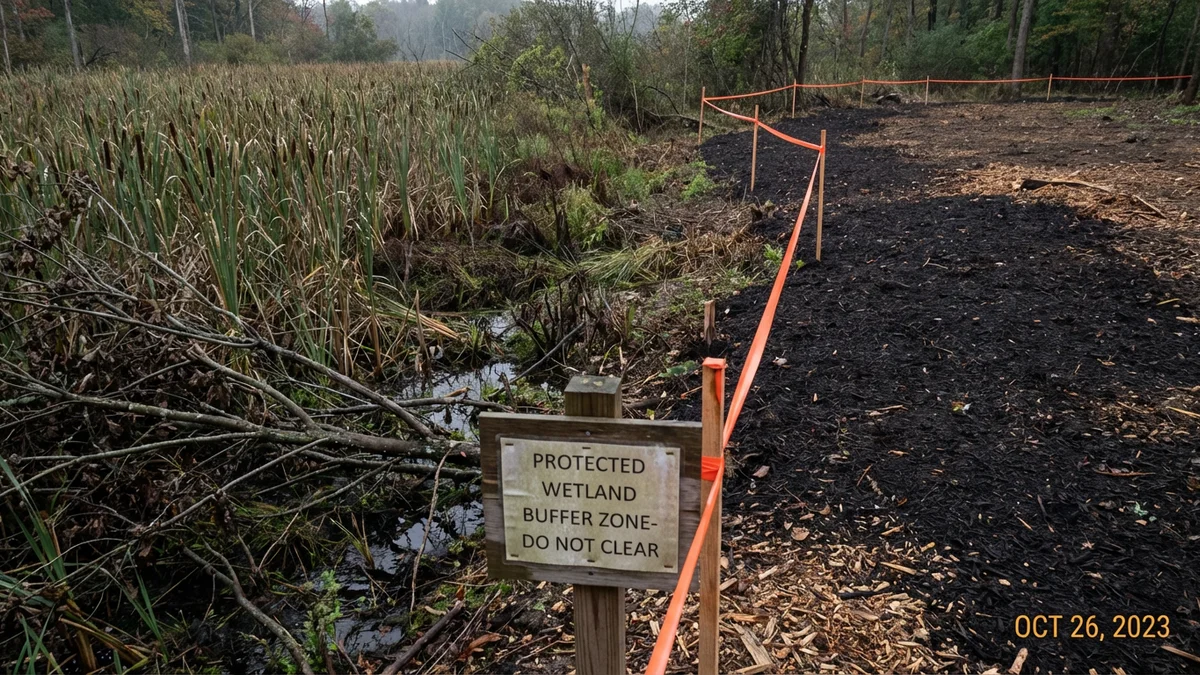
What forestry mulching does differently: Forestry mulching is better suited for work near buffer zones than most clearing methods because it doesn’t expose bare soil, doesn’t generate sediment runoff, and doesn’t remove the root systems that hold the soil in place. The mulch layer left behind actually mimics the protective function the buffer is designed to provide. This doesn’t make buffer work a free pass — the rules still apply — but it does mean that forestry mulching near a buffer boundary carries less erosion risk than bulldozing or hand clearing with exposed ground.
How Brush Busters Handles Buffer Zones
We assess every property for water features and buffer zones during the site visit. If your property borders a stream, river, pond, or mapped wetland, we identify the approximate buffer boundary and design the clearing plan to stay outside it. On properties where the clearing goal includes invasive species removal within or near the buffer, we discuss what’s likely permissible and what would require additional authorization.
We don’t provide legal or regulatory advice — we’re a land clearing company, not environmental consultants. But we’ve worked on hundreds of properties near waterways across Hunterdon, Somerset, Warren, and Morris counties, and we know how these situations are typically handled. If your project involves clearing within a buffer zone that requires NJ DEP authorization, we’ll tell you up front so you can pursue the appropriate approvals before scheduling work.
Our standard practice: clear right up to the buffer boundary and stop. That gives you the maximum usable area without triggering a regulatory issue. The mulch layer at the boundary’s edge actually provides a clean visual line that shows where maintained property ends and buffer zone begins.
Highlands Act and Buffers
If your property is in the Highlands Region, the buffer rules are layered on top of the standard NJ DEP regulations. The Highlands Act imposes additional protections on riparian areas, steep slopes, and environmentally sensitive lands within the Preservation and Planning Areas.
In the Highlands Preservation Area — which covers portions of Lebanon Township, Washington Township (Morris), High Bridge, Roxbury, and other municipalities in our service area — the buffer restrictions are enhanced. Clearing within riparian areas may require a Highlands Preservation Area Approval (HPAA) in addition to any standard DEP permits.
In the Highlands Planning Area, the Regional Master Plan provides guidance but doesn’t impose the same hard permitting requirements. Municipal conformance with the RMP varies, so the specific rules depend on whether your municipality has adopted the Highlands plan.
The practical takeaway: if your property is in the Highlands and borders a waterway, expect more restrictive buffer rules than properties outside the Highlands. Check both the standard NJ DEP regulations and the Highlands overlay before planning clearing work.
Common Questions
How wide is the buffer around wetlands on my NJ property?
Exceptional value: 150 feet. Intermediate value: 50 feet. Ordinary value: no required buffer. Measured from the wetland edge.
How wide is the riparian buffer along streams in New Jersey?
Category One: 300 feet. Category Two: 50 feet in the Highlands. The Musconetcong is C1. South Branch Raritan has C1 segments.
Can I clear invasive species from within a wetland buffer?
Selective invasive removal may be permissible where it improves ecological function. Check with NJ DEP for specific authorization. See our invasive species services.
How do I know if my property has wetlands?
Check NJ DEP GeoWeb for mapped wetlands. For a definitive answer, request a Letter of Interpretation. We identify obvious indicators during our site visit.
Is forestry mulching allowed near wetland buffers?
Mulching works right up to the buffer boundary. Within the buffer, restrictions still apply. Mulching is lower-risk than alternatives because it doesn’t expose soil. Learn about our forestry mulching method.
What is a Category One waterway?
The highest stream protection in NJ — 300-foot buffers. Designated for ecological significance, trout, or water supply. The Musconetcong is C1.
Does the Highlands Act add additional buffer requirements?
Yes. The Preservation Area has enhanced restrictions. Planning Area adds guidance. Read our full Highlands Act guide.
What happens if I clear within a buffer without authorization?
NJ DEP can impose fines, restoration requirements, and stop-work orders. Enforcement costs far exceed getting authorization in advance.
Can my farmer neighbor clear in the buffer because it's agricultural land?
Some pre-existing agricultural uses may be exempt. New clearing on previously undisturbed land in a buffer is generally not. The specifics depend on use history.
How does Brush Busters handle clearing near buffers?
We assess during the site visit, design plans to stay outside buffers, and flag anything that needs authorization before scheduling. Contact us for a site assessment.
Relevant City Pages
These city pages are a good fit if you want to compare the article advice with the kind of properties we see on the ground.
Related Articles
Forestry Mulching vs. Bulldozing: Which Is Right for Your NJ Property?
Forestry mulching vs. bulldozing for NJ properties: compare cost, speed, soil impact, and when each method makes sense.
See Forestry Mulching vs. Bulldozing: Which Is Right for Your NJ Property?
Land Clearing Cost Per Acre in New Jersey: Pricing Guide
New Jersey land clearing cost per acre explained: method, terrain, tree size, access, and how to compare quotes without getting burned.
See Land Clearing Cost Per Acre in New Jersey: Pricing Guide
Japanese Knotweed Removal in New Jersey: How to Actually Kill It
How to remove Japanese knotweed in New Jersey: identification, why it spreads, why cutting fails, and how mulching plus follow-up treatment works.
See Japanese Knotweed Removal in New Jersey: How to Actually Kill It
Want the full New Jersey land clearing playbook?
This article covers one piece of the puzzle. The complete guide ties together methods, costs, permits, terrain, and contractor selection in one place.
Not sure if your property has buffer restrictions?
Get a free site assessment — we'll identify water features, estimate buffer boundaries, and design a clearing plan that stays in compliance.
Or call (908) 774-9235.